 Blatnica je obec v stredoslovenskom kraji medzi Turčianskou kotlinou a Národným parkom Veľká Fatra. Je vstupnou bránou do najkrajších dolín Veľkej Fatry, Gaderskej a Blatnickej s vrchmi a jaskyňami a tak je ideálnym miestom pre počiatočný bod túr a cyklotúr. V jej blízkosti sa nachádzajú dominanty Turca – vrchy Tlstá (1373m) a Ostrá (1247m) na ktoré vedie trasa označená modrou turistickou značkou z Gaderskej doliny a trasa označená žltou značkou z Blatnickej doliny. Na trase na Tlstú je jaskyňa Mažarná v ktorej sa našli archeologické nálezy z praveku a staroveku. Nad obcou sa vypína vrch Plešovica so zbytkami valového opevnenia pre hradište. V 13. storočí bol vybudovaný Blatnický hrad, ktorého zrúcaniny sú 2 km od obce v Gaderskej doline.
Blatnica is a village in the Central Slovakia between Turčianska Bay and National Park Veľká Fatra (Great Fatra). It is the gateway to the most beautiful valleys of the Great Fatra, Gaderska and Blatnicka valleys with mountains and caves, so that it is an ideal starting point for hikes and cycle tours. In its vicinity, there are the dominants of Turiec - Tlstá Hill (1373m) and Ostrá Hill (1247m) on the tourist blue track leading from Gader valley and the yellow trail from Blatnická valley. On the route towards Tlstá Hill, there is the cave Mažarná, in which were found archaeological deposits of prehistoric and ancient times.
Above the village, Plešovica Hill stands up with the rest of a fortified settlement. In the 13th century, Blatnica castle was established, the ruins of which are 2 km away from the village, in the Gader Valley.
Vitajte v Blatnici / Welcome in Blatnica
Hotel-chata Gader v Gaderskej doline / Hotel - chalet Gader Gader Valley
Miestna šecialita, Gader káva / Local specialty, Gader coffee
Gaderská dolina / Gader Valley
Blatnický hrad z 13. storočia / Blatnica castle of 13th century
Blatnický hrad z 13. storočia / Blatnica castle of 13th century
Pohľad z Blatnického hradu na Malú Fatru /
View of Low Fatra from Blatnica castle
Pohľad z Blatnického hradu na Malú Fatru /
View of Low Fatra from Blatnica castle
Vrch Tlstá z Blatnického hradu / View of Tlstá Hill from the Blatnica castle
Pozrite si výstup na vrch Tlstá a jaskyňu Mažarná TU / View the climbing on Tlstá Hill and Mažarná Cave HERE
Pozrite si výstup na vrch Tlstá a jaskyňu Mažarná TU / View the climbing on Tlstá Hill and Mažarná Cave HERE
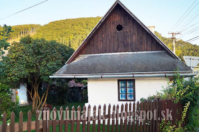
Blatnica was originally the settlement around the castle, which got abandoned in the late 18th century. In Blatnica, a very rare finding of the tomb of a Great Moravian magnate was found together with the Blatnický sword belonging to a group of Carolingian swords, which is a part of an exhibition in the National Museum of Budapest. The village attracts with its folk architecture, houses with arched closed gates dated to the late 18th century and early 19th century together with granaries along the Blatnica stream.
Dedinská architektúra / Village architecture
Dedinská architektúra / Village architecture
Stiahni si kml súbor - mapu pre Google Earth
Supporters of biking may be interested in a cycle route from nearby Martin to Blatnica through villages Košťany nad Turcom, Žabokreky, along the protected region of the mountains through the pictorial villages such as Belá-Dulice, Necpaly with four manor houses, and Folkušová. In the village of Belá Dulice, there is an access to Jasenská and Belianska valley. Hiking trails lead from there to the cottage Borišov, the waterfalls Došná, and Lysec Hill (1,381 m).The back route from Blatnica to Martin leads along villages Valentová and Príbovce. The biking route is 34 km long with gradients of 318 m. See the BIKING ROUTE
Download kml file- Map for Google Earth


Žiadne komentáre:
Zverejnenie komentára